


Spectacular weather forecasts
For eclipses, the Northern Lights, named winds and more

With fog, cloud, strong winds and rain, there are many ways that the weather can get in the way of seeing natural spectacles, but on the positive side there is more weather information available nowadays than ever before. I always like to know the back story with anything I use, such as who produces it, why they do that and how long it’s been around, so I thought I’d outline a few long-established options that are easy to use and some newer items too.
Observations In a post about weather forecasts, it might seem strange to start with observations but by looking at recent trends you can learn a lot about what the weather might do in the near future. For a general view, xcweather.co.uk has been around for more than twenty years and is great for a quick look at current conditions and recent trends in wind speeds. Originally designed to help paraglider pilots, the coverage includes the UK, France, Germany and Spain and there are some clear graphics for forecasts too.
XCWeather draws on observations from high quality weather stations and the Met Office’s Weather Observations Website (WOW) is another good source as not just any station is accepted and you can see a quality assessment under ‘Site Details’. It was established in 2011 and has observations worldwide from both official sources and individuals who operate their own instruments.
Nowcasts Meteorological services of course use more sophisticated forecasting approaches, blending observations and computer model outputs in a process called nowcasting. For the UK, the Met Office’s UK weather map is a great way of visualizing the results and is particularly useful for two of the more difficult things to forecast: rainfall and cloud cover. For example, a few days ago I saw that a Haar (coastal fog) was forecast locally and sure enough it rolled in as predicted at around 6pm. The next day though confirmed just how difficult fog is to forecast, but that’s another story!
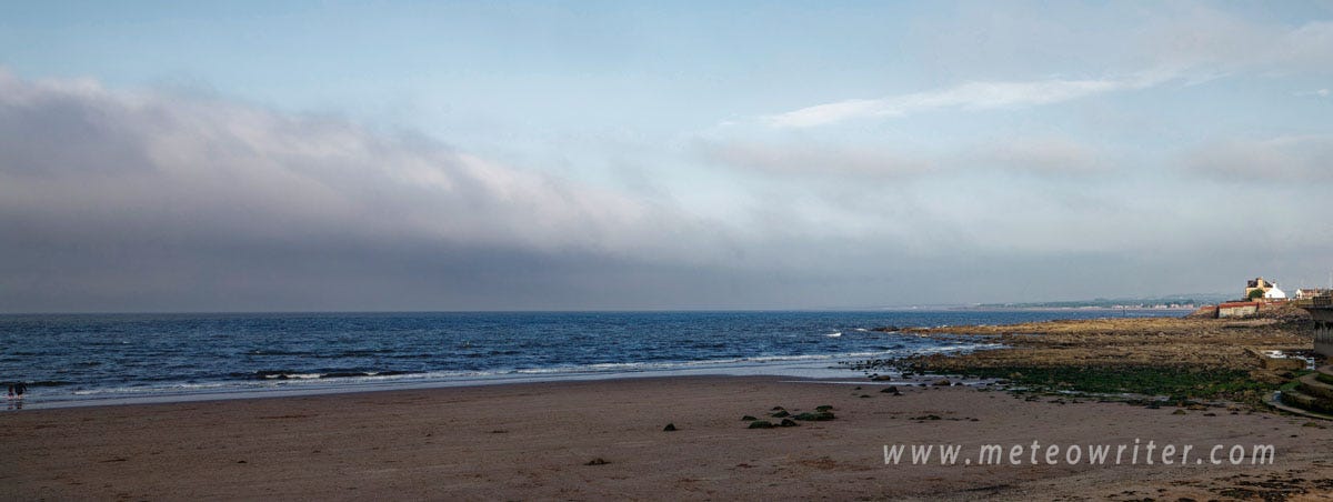
A Haar lurking offshore a few days ago before moving inland about half an hour later; Haar is a Scottish name for sea fog, similar to the sea frets of northeast England
Local weather forecasts Local experts can of course make much more of all this information and bring their own experience to bear. Even just a few years ago it was something of a ritual to catch an evening television forecast before a day out but you can now find regular video forecasts online, such as from the Met Office and BBC. The best forecasters give insights into how they’ve reached their conclusions, discussing air masses, the jet stream and other influences, and some include surface pressure charts. When choosing sources, simply pick the level of detail and style you like best, and it’s interesting to look at the online biographies of individual forecasters for clues as to their approach.
Specialist forecasts For some trips more detail helps, with mountain weather a good example. I’ve long been a fan of the Mountain Weather Information Service (MWIS) which was set up more than twenty years ago and provides forecasts for the UK’s main mountain areas. It was founded by Geoff Monk who used to work for the Met Office and saw the need for this kind of service in the UK. I once went to a workshop where Geoff gave a talk on MWIS and was really impressed when he got a long round of applause at the end when someone in the audience unprompted said he’d like to personally thank him for what he’d achieved; if you go to scientific meetings you’ll know that’s quite rare! Again, it’s that expert interpretation that’s really valuable and the Met Office’s more recent ‘Mountain Weather Forecasts’ have that too.
For the mountains, it’s also worth looking out for information from national parks, outdoor centres and so on, posted on websites or notice boards. For example, for winter walking in the Lake District, the Fell Top Assessor’s reports are invaluable and from December to March give detailed weather and snow condition observations from the top of Helvellyn, one of the Lake District’s highest peaks. A team of three experienced mountaineers takes it in turns to make the ascents, going out in even the most atrocious conditions.
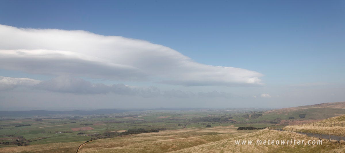
An example showing the northern end of an incipient Helm Bar, a spectacular cloud several miles long sometimes seen in Cumbria when Britain’s only named wind, the Helm, occurs, in this case spotted after a four hour drive based on a forecast from RASP
There are many other good examples of forecasting apps and websites, particularly for aviation, but I’ll briefly mention two more: RASP and windy.com. RASP was originally developed by Dr John (Jack) Glendening, a meteorologist and glider pilot, and gives insights into the inner workings of the atmosphere, such as atmospheric stability and vertical velocities; handy not just for top glider pilots but also for spotting unusual meteorological phenomena. Windy.com is another tool with a really well thought out user interface and can be used at many different levels, from a quick look at current conditions to comparing forecasts from different numerical weather prediction models.
So, hopefully that’s useful and just to end it’s worth saying that what works in one location may not in others, so it’s best to compare forecasts from different sources and over time do your own reality checks (or forecast verification if you prefer). This post also has a European flavour but hopefully the basic ideas apply elsewhere,.
Further Reading
From the author
Spectacular Britain, Kevin Sene, Bloomsbury, 2024, if you’d like to read more about named winds, the Helm and the Haar Link
Surfing the mountain waves; from tidal bores to atmospheric waves Link
Very interesting... and some useful websites!
Given the random way the haar was rolling in and out at Eyemouth two weeks ago I think it must be near impossible to predict in detail.